

ELA6350 and ELA6351 – Perseverance and Merrere Goldfields

ELA6410 - Bribbaree Goldfields
Central West Gold Project
The package comprising the Central West Gold Project is three exploration license applications, ELA6350, ELA6351 and ELA6410. The license applications combine to form a very large land package of 218 units or 654 sq. kms., equivalent to 65,400 hectares.
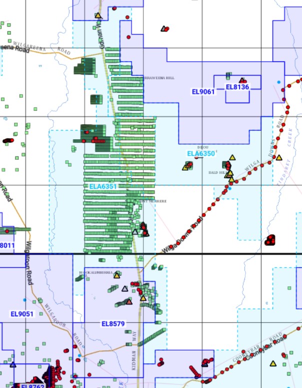
Licenses ELA6350 and ELA6351 are located approximately 50km north Cobar Town (around 45 minutes) and approximately 80km south of Bourke Town (around 1 hours 15 minutes).
Notice of Proposed Decision (NOPD) was received on 16 December 2021 proposing to grant ELA6350 and on 8 December 2021 proposing to grant ELA6351. This should be completed in Q1 2022. The NOPD for ELA6410 should be received in Q1 2022.
The appications were lodged by a wholly owned subsidiary of Minerals City Pty Limited, and upon grant will have a three year tenure and with expiration likley to be early 2025. Together ELA6350 and ELA6351 contain a large number of already identified mineral occurrences, and comprise seventeen separate known mineral occurrences containing gold, silver, copper, lead, iron and bismuth. A historical exploration reports suggests there are 70 old mines within the project areas.
Both ELAs have access to key infrastructure including roads, highways, regional airports, ports, water, and powerlines. Located within the Bourke and Cobar (1:250,000) Regional Geology Maps and included in the Central Lachlan Orogen, both are highly prospective with compelling regional-local geology, mineral occurrence data, historical exploration, and their to proximity and proven world-class discoveries. ELA6350 & ELA6351 are around 40 kms north east from the Glencore’s CSA high grade copper mines, 60 kms due north of Aurelia Metals Limited’s Peak Gold Mines, and 60 to 70 kms north west of Aeris Resources Limited’s Tritton Copper Mines.
ELA6350 contains a number of underground mines and workings, shafts and shallow pits including the Perseverance Mine where assays up to 15-17 g/t Au, with 4-7 g/t Au in the wall rocks were recorded. ELA6351 contains the Merrere Gold Fields where there are a number of underground mines and workings, shafts and shallow pits where a New South Wales Department of Mines annual report for 1882, p 100, notes that 0.2t of ore had a yield grade of 274 g/t Au and 840 g/t Ag at Burton’s Shaft. The Lone Hand Mine Mine Record 2126 states that the formation carries about 2-1/2 dwts (3.8 g/t) of gold across a belt about 400 feet (130 m) wide, at 100 foot level (30 m).
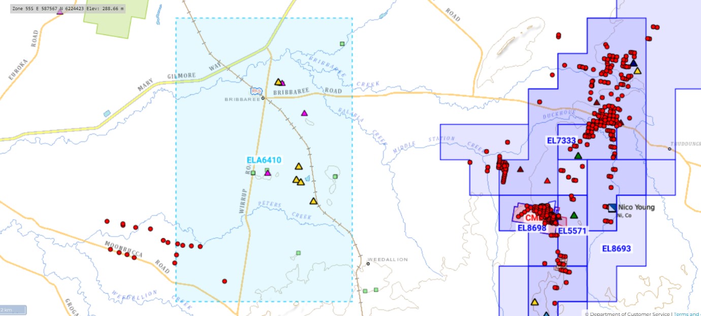
The Bribbaree Gold Project consists of one exploration license application ELA6410. The license application covers an area of approximately 144 sq kms or 14,400 hectares of the Eastern Lachlan region of New South Wales. The southern boundary of EL6410 is located approximately northwest of Young and 36 kms southwest of the township of Grenfell. Bribbaree is located 424 kms west of Sydney. Bribbaree is at an elevation/ altitude/ height above sea level of 258 m above sea level. The application was made by a wholly owned subsidiary of Minerals City Pty Limited. Upon grant the exploration license will have a term of three (3) years from Q1 2022, both Q1 2025.
The Bribbaree Gold Project is hosted within Lachlan Orogen Fold Belt. Regionally, the Cootamundra 1:250 000 map sheet area is located in the southern part of New South Wales and is bounded In latitudes 34 o00'S and 35o00'S and longitudes 147 o00'E and 148o30'E and covering an area of 6000 square kilometres. The principal towns within the map area are Cootamundra, Young, Junee, Coolamon. Temora, Barmedman, and Harden-Murrumburrah.
The Cootamundra 1:250,000 map sheet area has a history of metalliferous mining extending back to the early 1850s. The area has been a significant gold, silver and magnesite producer. A number of different mineralisation styles is present. These include:
- late Ordovician to early Silurian porphyry copper–gold systems
- epithermal gold–silver and base metal systems of varying ages
- orogenic gold (and base metal) mineralisation
- podiform chromite deposits and Tertiary lateritic nickel–cobalt, and
- sediment-hosted magnesite deposits.
Minor tin, manganese and alluvial diamonds have also been recovered. In addition, major gold-bearing placer deposits have been mined in a number of areas, most notably near Young and Temora.1
Gold is by far the most widely distributed and commonly occurring metallic mineral within the Cootamundra 1:250,000 sheet area. It occurs within and adjoining widely differing rock types, from ultrabasics to granite and sediment, and within all the major structural zones represented. A large number of the old mines shown on the associated maps were visited.
The Bribbaree Gold Project is located within the Cootamundra (1:250,000) Geologican & Metallogenic Maps This area has a history of metalliferous mining extending back to the early 1850s. The area has been a significant gold, silver and magnesite producer. A number of different mineralisation styles is present. These include:
- late Ordovician to early Silurian porphyry copper–gold systems
- epithermal gold–silver and base metal systems of varying ages
- orogenic gold (and base metal) mineralisation
- podiform chromite deposits and Tertiary lateritic nickel–cobalt, and
- sediment-hosted magnesite deposits.
Contains several excellent historical mines and occurreces with details:
- The Bribbaree Gold Mines, one of the famous historical mines in the Bribbaree and Macquire Arc, Lachlan Orogen, New South Wales.
- The Bonanza Mine, The Brilliant Mine, and The Wee Jimmie Mine, the old historical mines in the Bribbaree that produced gold as major ore for unknown period
- Several pit and grid that contain unprocessed construction materials.
The project areas have been largely untested by modern exploration and drilling.

1Downes, P. M. (2004). Mineral deposits and models, Cootamundra 1:250,000 map sheet area. ISSN 0155-3410. New South Wales